Chisvingo and Nhunguza monuments, Masembura Communal Lands
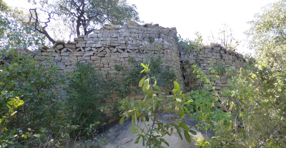
Chisvingo Ruins are located in the Masembura Communal Lands in Mashonaland. The name comes from the Shona Rusvingo; stone wall, or fortification. Little excavation work has been carried out; but the nearby Nhunguza Ruin, 1.5 kilometres to the northeast was excavated by Peter Garlake in 1972 and dated to the sixteenth Century. Much of the notes below relate to Nhunguza Ruins below as Chisvingo and Nhunguza ruins are very similar in their style and type of dry-stone walling and Peter Garlake classifies them both as Zimbabwe-type ruins. Chisvingo Ruin comprises a single curved enclosure shaped somewhat like an open horseshoe. The dry-stone walling encloses the northern, eastern and southern sides leaving the east side open to the extent of 30 metres. The diameter of the ruin is about 35 metres and the enclosure area would originally have been surrounded by pole and dhaka huts, but no trace of these remains. Like Nhunguza, Chisvingo is not on an easily defended site, but all the surrounding hilltops are visible on every side, and it is in attractive brachystegia woodland and occupies a level saddle between granite kopjes with extensive views. In common with all these ruins, land suitable for grazing and agriculture surrounds the site. The close fitting, dressed and coursed granite walls have a chevron and herringbone pattern and Garlake thinks they might have once had a dentelle frieze. Later alterations include the blocking of a rounded entrance.
Both these ruins and others were described by early hunters and explorers. The archaeologist J.T. Bent positions Chisvingo Ruin accurately, but did not visit, and called it Chipadzi’s Ruin as it is near the kraal of this name. Chisvingo Ruins is 24 kilometres down the Pote River from the Yellow Jacket Ruins. The Mazowe River joins the Pote River just above Shamva; and the area has many goldfields with numerous “ancient workings” and written accounts by the Portuguese in the sixteenth century of alluvial mining for gold. Garlake makes the point that besides these ruins, there are a number of sixteenth century Portuguese trading posts at Dambarare, Matafuna, Bocuto, Massapa and Luanze easily accessible from the Mazowe River with their base at Tete on the Zambezi River
Umfurudzi Park

The Park covers an area of 76,000 hectares is bounded on its eastern edge by the Mazowe River with the Umfurudzi River flowing through the southern portion of the park before joining the Mazowe River. This eastern boundary forms the provincial boundary between Mashonaland Central, within which the Park lies, and Mashonaland East.
The Safari Park was the first to be opened after Independence in 1980, but the wildlife was very adversely affected by political and social turmoil, poaching and over-hunting, and the collapse of tourism, and the withdrawal of international funding. In the 1990’s the area was under the protection of the Wilderness Africa Trust and they were optimistic for the future of the area including wildlife protection and relocation, volunteer help and community training. However, the lack of visitors and the land chaos after 2000 turned these dreams into a nightmare.
The Umfurudzi Park is safe to walk anywhere outside of the protected and fenced buffalo breeding area and there are many marked walking trails and roads within the Park. With special arrangements with management, multi day walking and wilderness camping in the park is available to the seasoned hiker, including climbing Mt Chisinga, Svisamoyo and other mountains, or granite kopjes. Visits may be made to numerous San rock art sites, potholes and Iron-Age dry-stone walling monuments. Walking within the intensive breeding area is allowed with the attendance of a Park Ranger because it contains dangerous animals, namely Buffalo and Elephant.
Restocking of wildlife has taken place and management at the Safari Park has reasserted organisation and discipline and brought the poaching problem under control with the Park Rangers undertaking anti-poaching patrols with the aid of added vehicles and equipment such as short wave radio handsets.
The Umfurudzi Park has completely recovered so that today it can offer a wide variety of attractions including vast areas of natural woodlands, wildlife, Iron Age dry-stone walling monuments, rock art, fascinating potholes worn into the granite by river action and good fishing for tigerfish, bream, vundu and chessa in a comfortable and safe environment.
Kariba Dam
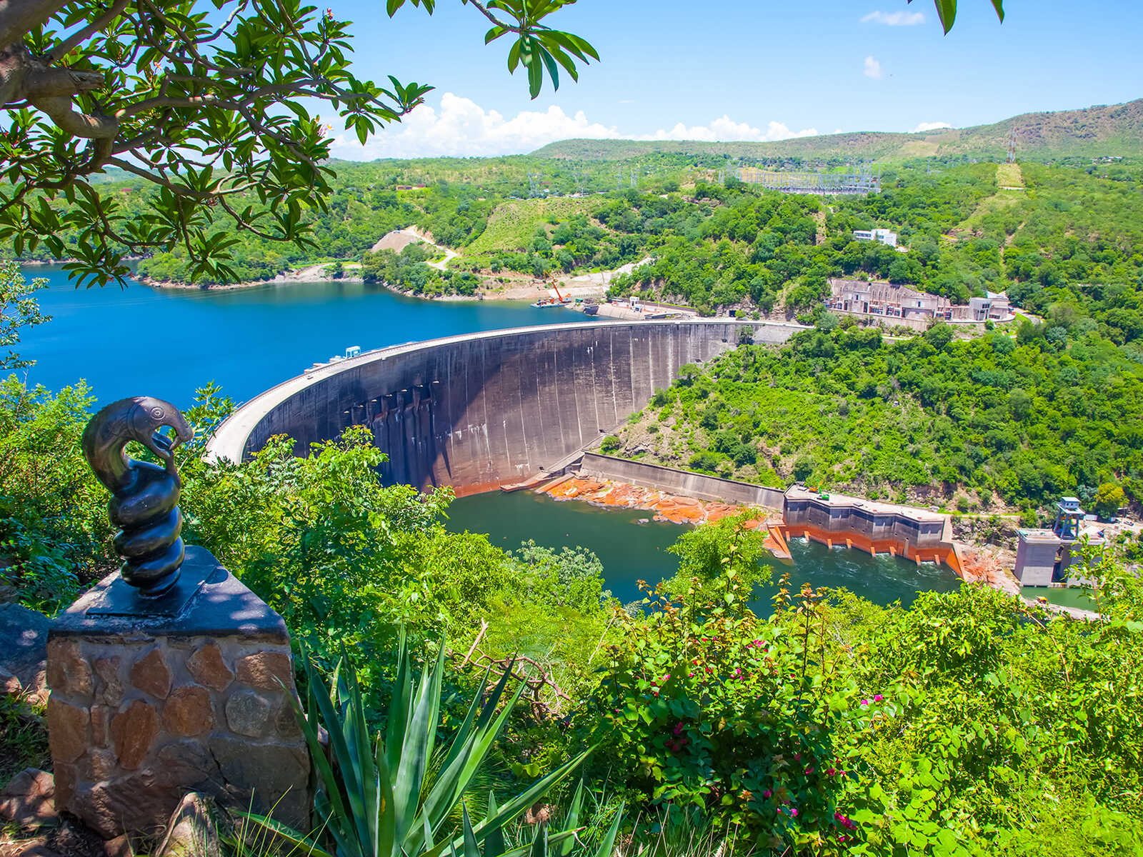
The Kariba Dam is a double curvature concrete arch dam in the Kariba Gorge of the Zambezi river basin between Zambia and Zimbabwe. The dam stands 128 metres and 579 metres. The dam forms Lake Kariba, which extends for 280 kilometres and holds 185 cubic kilometres of water.
Chinhoyi Caves

The Chinhoyi Caves are a group of limestone and dolomite caves in north central Zimbabwe. Designated a National Park in 1955, and managed by the Zimbabwe Parks & Wildlife Management Authority.
Mazvikadei Dam
Mazvikadei Dam is a dam in Zimbabwe which provides water for farm irrigation. It is the third largest dam in Zimbabwe.